Walking in Croxley Green

Croxley Green offers many opportunities for walking, from a gentle VILLAGE WALK to the very scenic 10km BOUNDARY WALK. Why not try one of the CROXLEY LOOPS or explore the COMMON MOOR? Each page shows a map and description of the route as well as points of interest along the way.
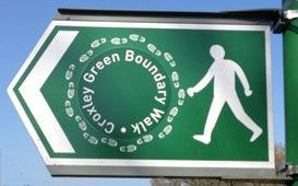
Beating the bounds has long been a countryside tradition, apparently to prevent children from getting lost! It has since been used as a way of keeping footpaths clear and open to the public and in 2012 Croxley Green Parish Council purchased signage to mark out the CROXLEY BOUNDARY WALK. Since 2013 there has been an annual run /walk on New Year’s Day around the 10km (6.3 mile) circular route. Our new HISTORICAL BOUNDARY WALK (2023) guide includes some of the sites and former sites of historical interest along the way. Starting on the Green, it passes through some lovely woodland and open fields, skirts along the canal, past the former site of Dickinson’s paper mill, continuing over the moor and along the Ebury Way, past the Great Barn, Scotsbridge Mill and the river Chess and back to the Green.
Beating the bounds has long been a countryside tradition, apparently to prevent children from getting lost! It has since been used as a way of keeping footpaths clear and open to the public and in 2012 Croxley Green Parish Council purchased signage to mark out the CROXLEY BOUNDARY WALK. Since 2013 there has been an annual run /walk on New Year’s Day around the 10km (6.3 mile) circular route. Our new HISTORICAL BOUNDARY WALK (2023) guide includes some of the sites and former sites of historical interest along the way. Starting on the Green, it passes through some lovely woodland and open fields, skirts along the canal, past the former site of Dickinson’s paper mill, continuing over the moor and along the Ebury Way, past the Great Barn, Scotsbridge Mill and the river Chess and back to the Green.
We are slowly adding all possible locations that appear on the Croxley Green history website and you can browse the web pages via location. The locations are categorised as you can see below
Categories on the map above
Hertfordshire Definitive Rights of Way
Use the link below to load the definitive public rights of way into your Google Maps app. The definitive map, together with the definitive statements, is a legal record of public rights of way in Hertfordshire. It's based on information which was correct in December 2015, plus confirmed orders made since.
https://tinyurl.com/bd6y634a
https://tinyurl.com/bd6y634a


